Home > NYC Reports > 1906
Work on the system began on August 1, 1905 with the appointment of the Chief Engineer and a Division Engineer. On October 27, 1905 New York City approved the plans for the new water system, with New York State approval being obtained on May 14, 1906. By the end of 1906, the planned final height of the reservoir had not yet been determined. The combination of Rye Pond and the existing Lake Kensico had been seen as a desirable location for a large equalizing reservoir as early as 1895, able to provide 50 days of supply if there was a disruption further north on the aqueduct. Quick planning for the new dam and reservoir was seen as important since property values were rising rapidly in the area, increasing the city’s acquisition costs. In addition, the reservoir was seen as a quick way to address a water emergency should drought conditions develop, since water from this watershed could be delivered through the existing Bronx Conduit. By the end of the year, two dam sites had been investigated and 500 acres had been identified for acquisition. The dam sites were both above and below the current 1885 dam, with most test borings done below the dam since this was seen as the more favorable site. Soil samples from different areas of the planned reservoir were sent to the chemist to determine if soil stripping would be necessary.
A Chief Photographer was appointed on July 19, 1906 and in the first 5 months 213 photographs were taken. I personally would like to thank the Chief Photographer and his staff for their record of the construction of the water system since without them this whole section of the website wouldn’t exist.
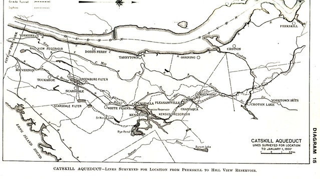
Map of the aqueduct and reservoir from 1906. Notice the peninsula at the northern end of the reservoir appears as an island since the final height of the reservoir had not yet been determined.
The earlier 1885 dam, located in what is now the Kensico Dam Plaza. At this time it was expected that the new dam would be in front of this dam and 105 feet taller.
Bear Gutter is in the foreground and Lake Kensico is in the background. Pfister’s store is to the right just outside the photograph. This area is now under about 100 feet of water.
Home | Historical Society Photos | 1907 Report | Site Map
Synopsis written by Robert Mortell, 2013.